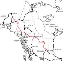
The Alaska Highway Dawson Creek, British Columbia to Delta Junction, Alaska (historical routes, heritage sites, sightseeing, driving tour) Pioneer Road - Contract Road - Public Road
HISTORY - Pre-Construction The Canol Pipeline 1942
The Canol pipeline was built to carry crude oil from Norman Wells, Northwest Territories, in Canada to Alaska, USA, during World War II. The routing was to Johnson Crossing and then along the Alaska highway to Whitehorse, Yukon, where a refinery was built. Ref.
Even though the pipeline was on Canadian territory, as a wartime expediency the building of the pipeline was overseen by the United States Army. Local workers were employed as well as civilians recruited in the South. Recruiting ads warned candidates not to apply unless they were prepared for the "harshest possible conditions".
Construction began in 1942, and was completed in April 1944. The pipeline was just 4 inches (102 mm) in diameter. The light crude oil from Norman Wells could be run through a narrow pipeline without being heated, where heavier crude requires heating.
The pipeline's main line was in use for less than fourteen months (1943/12/19-1945/04/01). The Canol pipeline actually consisted of four sections. Although the Norman Wells section was shut down, oil was received from Skagway and pumped to Fairbanks and a pipeline was also extended from Whitehorse to Watson Lake. The pipeline's route is now a wilderness hiking trail—the Canol Heritage Trail.
CBC News reported that 20 percent of the oil shipped through the pipeline is unaccounted for. The Norman Wells Museum contains skulls of Moose and Caribou that died when their antlers were caught in wires that ran parallel to the pipeline. They reported that, when the war ended, American forces had simply abandoned all their infrastructure, making no effort to remediate the environmental damage the pipeline had caused.
The Canol Road was part of a project to build the Canol pipeline and a road from Norman Wells, Northwes Territories, to Whitehorse, Yukon, during World War II. The pipeline no longer exists, but the 449 kilometres (279 mi) long Yukon portion of the road is maintained by the Yukon Government during summer months. The portion of the road that still exists in the NWT is called the Canol Heritage Trail. Both road and trail are incorporated into the Trans-Canada Trail. More
The Canol Heritage Trail is a 355-kilometre-long (221 mi) trail running from Norman Wells, Northwest Territories, through the Mackenzie Mountains, to the Yukon border. Because of its remoteness, length and river crossings, it is considered one of the most challenging trails in Canada.The trail is in the process of becoming a territorial park. More Information
The Alaska Highway Dawson Creek, British Columbia to Delta Junction, Alaska (historical routes, heritage sites, sightseeing, driving tour) Pioneer Road - Contract Road - Public Road