The Alaska Highway Dawson Creek, British Columbia to Delta Junction, Alaska (historical routes, heritage sites, sightseeing, driving tour) Pioneer Road - Contract Road - Public Road
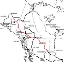
Even though the first three routes looked at were not chosen, the needs of war dictated the final route, which was intended to link the airfields of the Northwest Staging Route that conveyed lend-lease aircraft from the United States to the Soviet Union. It had been completed in the Fall of 1941. Thus the long, impractical route over difficult terrain was chosen.
The official start of construction took place on March 8, 1942 after hundreds of pieces of construction equipment were moved on priority trains by the Northern Alberta Railways to the northeastern part of British Columbia near Mile 0 at Dawson Creek.
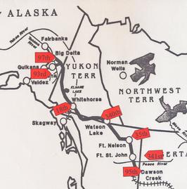
The road was originally built mostly by the U.S. Army Corps of Engineers as a supply route during World War II. In 1942, the Army Corps of Engineers assigned more than 10,000 men, about a third were black soldiers, members of three newly formed "Negro regiments". There were four main thrusts in building the route: southeast from Delta Junction, Alaska toward a linkup at Beaver Creek, Yukon; north then west from Dawson Creek (an advance group started from Fort Nelson, British Columbia after traveling on winter roads on frozen marshland from railway stations on the Northern Alberta Railways); both east and west from Whitehorse after being ferried in via the White Pass and Yukon Route railway. The Army commandeered equipment of all kinds, including local riverboats, railway locomotives, and housing originally meant for use in southern California.
18th Engineer Combat Regiment would start at Whitehorse and work north.
35th Engineer Combat Regiment would start at Fort Nelson and work north.
The 93rd Engineer General Service Regiment (colored) started at Sina, Akaska and worked toward Tok, Alaska
The 95th Engineer General Service Regiment (colored) started at Dawson Creek
The 97th Engineer General Service Regiment (colored) started at Big Delta working south toward the Yukon
340th Engineer General Service Regiment would start at Whitehorse and work south.
341st Engineer General Service Regiment would start at Fort St. John and work north.
U.S. Army Regiments
Construction was slow at first with under 100 miles constructed in the first month, but accelerated through the spring as the winter weather faded away and crews were able to work from both the northern and southern ends; they were spurred on after reports of the Japanese invasion of Kiska Island and Attu Island in the Aleutians.
During construction the road was nicknamed the "oil can highway" by the work crews due to the large number of discarded oil cans and fuel drums that marked the road's progress.
On September 24, 1942 crews from both directions met at Mile 588 at what became named Contact Creek, at the British Columbia-Yukon border at the 60th parallel.
The entire highway was completed on October 28, 1942 with the northern linkup at Mile 1202, Snag Creek (now Beaver Creek).
The Alaska Military Highway was dedicated on November 20, 1942 at Soldier's Summit.
Some 100 miles (160 km) of route between Burwash Landing and Koidern, Yukon, became nearly impassable in May and June 1943, as the permafrost thawed, no longer protected by a layer of delicate vegetation. A corduroy roa was built to restore the route, and corduroy still underlays old sections of highway in the area. Modern construction methods do not allow the permafrost to thaw, either by building a gravelberm on top or replacing the vegetation and soil immediately with gravel. The Burwash-Koidern section, however, is still a problem as the new highway built there in the late 1990s continues to experience frost heave.
Although it was completed on October 28, 1942 and its completion was celebrated at Soldier's Summit on November 21 (and broadcast by radio, the exact outdoor temperature censored due to wartime concerns), the "highway" was not usable by general vehicles until 1943. Even then there were many steep grades, a poor surface, switchbacks to gain and descend hills, and few guardrails. Bridges, which progressed during 1942 from pontoon bridges to temporary log bridges, were replaced with steel bridges where necessary. A replica log bridge, the Canyon Creek bridge, can be seen at the Aishihik River crossing; the bridge was rebuilt in 1987 and refurbished in 2005 by the Yukon government as it is a popular tourist attraction. The easing of the Japanese invasion threat resulted in no more contracts being given to private contractors for upgrading of specific sections.
The Alaska Highway Dawson Creek, British Columbia to Delta Junction, Alaska (historical routes, heritage sites, sightseeing, driving tour) Pioneer Road - Contract Road - Public Road