Alaska Storyteller Photography

© Robert M. Braley Jr., Photographer

Home

United States

Alabama

Alaska

Anchor Point

Anchorage

Alaska Highway

Alaska Natives

Alaska 2015

Big Lake

Chicken

Chickaloon

chugiak

Copper Center

Cold Bay

Cooper Landing

Cordova

Cottonwood Creek

Civil War Alaska

Delta Junction

Denali Park

Elmendorf AFB

Eureka

Fairbanks

Girdwood

Glennallen

Hatchers Pass

Healy

Houston

Historic Mileposts

Homer

Hope

Hyder

Kenai

King Cove

Kodiak

Kulis Reunion 2017

Lake Louise

Nenana

Ninilchik

North Pole

Palmer

Palmer Hay Flats

Potter Marsh

Reflections Lake

Rabbit Slough

Richardson Highway

Russian America

Sand Point

Seward

Sitka

Soldotna

Sterling

Captian Cook

Southeast

Swan Lake

Arkansas

Arizona

California

Bakersfield

Fort Crook Museum

George AFB

Klamath AFS

Klamath WWII Radar

Redwood NP

San Francisco

Samohi

Santa Monica

Venice

Whiskeytown

Colorado

Connecticut

Delaware

Florida

Georgia

Hawaii

Pearl Harbor

Kansas

Kentucky

Idaho

Illinois

Indiana

Louisiana

Iowa

Ohio

Oregon

Ashland

Lithia Park

Oregon Coast

Maine

Maryland

Massachusetts

Michigan

Minnesota

Mississippi

Missouri

Montana

Nebraska

Nevada

New Hampshire

New Jersey

New York

New Mexico

Ruidoso

North Carolina

North Dakota

Oklahoma

Pennsylvania

Rhode Island

South Carolina

South Dakota

Tennessee

Texas

Utah

Vermont

Virginia

Washington

Anacorties

Anacortes WA

Centralia WA

Chehalis WA

Elbe WA

Lewis County WA

Mt Rainer

Olympia WA

Steilacoom WA

Tacoma

Washington D.C.

Wisconsin

West Virginia

Wyoming

Canada

British Columbia

100 Mile House

108 Mile House

Chetwynd

Dawson Creek

Dawson Creek VC

Dawson Creek DT

Hope BC

Hudsons Hope

Pouce Coupe BC

Stewart BC

Yukon

Crete

Equator

Israel

Products

Nature

Animals

Flowers

Landscapes

Sunset

Wildflowers

Wildlife

Fish

Birds

Albatrosses

Canada Goose

Comorants

CaracarasFalcons

DucksGeeseSwans

Frigatebirds

Grebes

Loons

Osprey

PartridgesGrouse

Pelicans

redwingedblackbird1

HawksKitesEagles

ShearwatersPetrels

StormPetrels

Bats

Vultures

Mammals

Black Bear

bison

BitternsHeronsEgr

Caribou

Carnivorans

Cetaceans

Dall Sheep

Deer

Moose

Mountain Goat

Seals Sea Lions Walrus

Orca

Pikas Hares Rabbits

Polar Bear

Primates

Raccoons

Rodents

Great blue heron

Shrews

Bears

Beaver

Ungulates

Weasels

Military

C-17

T-6G

T-33

P-51 Mustang

KC-135

HH-60

F-86

F-80

C-47

HC-130N

C-130H

C-130E

C-123J

Alaska National Guard

Alaska Air National Guard

Camp Murray

Alaskanized

Ladd AFB

AKNG Museum

U-Tapao

Pixels

links

About

Policy/Copyright

Contact

Photo Sizes

The Alaska Highway
Dawson Creek, British Columbia to Delta Junction, Alaska
(historical routes, heritage sites, sightseeing, driving tour)
Pioneer Road - Contract Road - Public Road
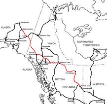
Travel along the Alaska Highway via the Historic Mileposts

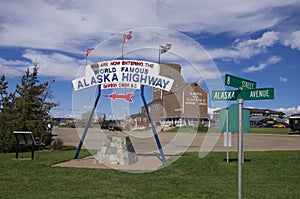
Alaska Highway Sign
Alaska Highway Historic Mile 0

Charlie Lake, British Columbia, Canada
Alaska Highway Historic Mile 52

Art Prints
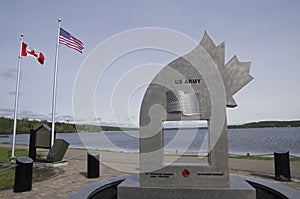
Memorial
Historic Mile 52


WWII Vintage Military Memorial
Alaska Highway Historic Mile 52

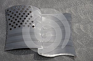
Metal United States Flag
Alaska Highway Historic Mile 52

Historic Mile 52 Charlie Lake Mile 0 Army Tote Road. Site of a major distribution camp for workers and supplies heading north. Three American soldiers also drowned here in 1942 while crossing the lake aboard “pontoon bargers.”

Charlie Lake Provincial Park
Alaska Highway Historic Milepost 52


The campsites are large, on gravel pads with lots of trees which are mostly aspen.

The park is located 11 km north of Fort St. John at the junction of the Alaska Highway and Highway 29

  • Operator or sponsor is: BC Parks
  • Nearby town or city: Fort St. John
  • Total campsites: 57
  • Unserviced campsites: 57
  • Tables provided at campsites
  • Tap water available
  • Pit toilets
  • Recycling collection at campground
  • Sewage dumping station
  • Hiking trails
  • Playground
  • Picnic shelter
  • Day use area
  • Wheelchair access
  • Horseshoe pits
  • Boat launch

More information and photos at Campscout.com

Charlie Lake is a lake in north-eastern British Columbia, Canada, situated 8 km (5.0 mi) west from Fort St. John, along the Alaska Highway. The lake provides the water supply for the city of Fort St. John. The Charlie Lake Formation, a stratigraphical unit of the Western Canadian Sedimentary Basin is named for the lake.

Source: Wikipeda

BACK

The Alaska Highway
Dawson Creek, British Columbia to Delta Junction, Alaska
(historical routes, heritage sites, sightseeing, driving tour)
Pioneer Road - Contract Road - Public Road
NEXT

Website powered by Network Solutions®